• TOP>
  • Geo Sites

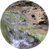
Northern Uwakai Area [Rias Area] Kurosegawa River Area [Geo Area] Shikoku Karst/Funato River Area [Karst Area] Hijikawa River Upstream Area [Village Area] R1 Suzaki Coast R3 Karihama Terraced Farm V1 Unomachi's street V2 Top 100 famous springs, Kannonsui (a spring) V3 Katsuragawa Valley V4 The Pot Hole of Owada Bridge G1 Oriai Submarine Landslide G3 Mitaki Valley G4 Anagami Limestone Cave G5 Nakatsugawa Tufa K1 Beech Virgin Forest K2 Genjigadaba (a mountain) K3 Terayama Pillow Lava K7 Landslide and Doi Residence of Sogawa

Northern Uwakai Area [Rias Area]

R1Suzaki Coast

Shuki 1-3-1, Mikame Town, Seiyo City, 33°21’49.8″N 132°23’08.3″E Part of the Kurosegawa Tectonic Zone. These vertically striped rocks are called “tuff”, and are made of consolidated volcanic ash. Tectonic movements caused this originally horizontal strata to become a vertical rock face that it is today. There is a boardwalk, some 300m long, offering a breathtaking view of the wall up close.

R3Karihama Terraced Farm

Karihama 3-208-5, Akehama Town, Seiyo City, 33°18’57.5″ N 132°27’33.3″E The Nanyo District in Ehime Prefecture is famous for its terraced fields. Especially in Karihama, delicious oranges are grown in terraced fields made with stone walls built with limestone and other stones. In this area, sardine net-fishing used to prosper, while on the land, people made terraced fields to cultivate sweet potatoes and barley. Later, terraced fields came to be used as mulberry fields for raising of silkworms, and stone walls were built to prevent runoff of fertilizer for the mulberries. About 60 years ago, orange cultivation started at full scale. This whole area was designated as an Important Cultural Landscape by the government under the name “Uwa Sea Karihama terraced fields and fishing and agricultural village landscape”.

Hijikawa River Upstream Area [Village Area]

V1Unomachi’s street

Unomachi 3-106, Uwa Town, Seiyo City, 33°21’50.6″N 132°30’49.8″E The streets from Edo to early Showa era (17th to early 20th century). The area is selected as one of the Important Preservation Districts for Groups of Traditional Buildings by the country, for its distinctive white plastered walls and latticed windows.
Along this street, a traditional Japanese sake brewer, a soy-sauce brewer and other shops do business. Also, you can experience a Meiji-era lesson in Kaimei School, a National Important Cultural Property, in which German glass is used for the arched windows.

V2Top 100 famous springs, Kannonsui (a spring)

Akanma 3478, Uwa Town, Seiyo City, 33°20’15.9″N 132°35’02.1″E The spring water flows from the limestone cave, and has been chosen as one of the top 100 natural water sources in Japan. The water, which is pumped daily for an average of 8,000t in volume, is slightly alkaline, and the temperature is kept at 14 °C through all seasons. Flowing somen noodles can be enjoyed at Meisuitei, which opens during summer.
TEL:+81-894 (67) 0013 *Meisuitei

V3Katsuragawa Valley

Nomura 17-59-3, Nomura Town, Seiyo City, 33°21’15.0″N 132°38’26.2″E The valley is famous for its stunning crystal clear water, which flows through the deep green of the forest. The hard rocks called chert are etched by the valley, with the area lined by a series of rocky walls, waterfalls, and rock formations. A tragic legend holds this place to be where a princess called Otogoze once threw herself into the water.
*Katsuragawa Valley was severely affected by the 2018 Japan floods, and the landscape is not the same as before.

V4The Pot Hole of Owada Bridge

Onishi 3-3, Nomura Town, Seiyo City, 33°23’48.9″N 132°40’17.4″E Along Hijikawa River, you can observe rocks including the oldest igneous rocks and limestone in Shikoku, which make up Kurosegawa Tectonic Zone. Here you can also observe small land features called potholes, which are formed by pebbles and strong currents.

Kurosegawa River Area [Geo Area]

G1Oriai Submarine Landslide

Oriai 1015-1, Shirokawa Town, Seiyo City, 33°22’48.4″N 132°44’56.9″E At the riverbed of Kurosegawa River, limestone blocks are absorbed into the mudstone that accumulated in the deep seafloor. The limestone contains fossils of coral and shells among others, and was formed in the shallow waters. Here you can see how the rocks moved significantly from the land toward the seabed, for reasons including earthquakes.

G3Mitaki Valley

Kubono 2087, Shirokawa Town, Seiyo City, 33°24’34.0″ N 132°47’29.0″ E The area is the locality of “Mitaki igneous rocks”, which make up Kurosegawa Tectonic Zone, and here you can find its iconic rocks. The valley itself is breathtakingly beautiful too; along the boardwalk set up in the valley, visitors can enjoy its waterfalls of various sizes and the nature that changes its face every season.

G4Anagami Limestone Cave

Kawazuminami 3612, Shirokawa Town, Seiyo City, 33°23’04.8″ N 132°49’07.3″ E A 75m long boardwalk is installed along the cave, which is made of limestone from the Jurassic period of the Mesozoic era, and stretches for a total of 300m. Stalagmites and stone pillars are preserved carefully, offering a mysterious world of limestone caves. Reservation required for admission.
TEL:+81-894 (83) 1008 *JA Kawazuminami Branch Office

G5Nakatsugawa Tufa

Furuichi 2558, Shirokawa Town, Seiyo City 33°22’52.7″N 132°46’58.1″E “Tufa” derives from Latin, and means “a white stone with small holes”. The rock is formed when calcium carbonate rapidly precipitates into the water that is rich in lime content, and this deposition is thought to be related to the activities of microbes.

Shikoku Karst/Funato River Area [Karst Area]

K1Beech Virgin Forest

Onogahara 156, Nomura Town, Seiyo City, 33°29’43.6″ N 132°52’00.4″ E A vast Beech Virgin Forest of about 75ha. The area is called the “forest mother” for making the soil fertile, and the water stored from this virgin forest supports the lives of the community and their livestock. Through the roughly 1.2km long boardwalk, visitors can enjoy forest bathing with the view of dainty alpine plants.

K2Genjigadaba (a mountain)

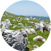
Onogahara 240, Nomura Town, Seiyo City, 33°28’20.9″ N 132°51’58.2″ E Shikoku Karst is one of Japan’s three major karsts. The highest point that rests on its western tip commands a panoramic view of the mountains of southwestern Shikoku, at an altitude of 1,402m. Karst tableland is a gently rolling landform in which limestone has been dissolved by rainwater. The limestone you can see here and there like a flock of sheep is called Karrenfeld.

K3Terayama Pillow Lava

Onogahara 436-2, Nomura Town, Seiyo City, 33°29’14.1″N 132°53’42.2″E The basalt is the lower formation of Shikoku Karst’s limestone. This basalt was formed when lava flowed into the water after an eruption of a submarine volcano, which cooled rapidly and solidified. The rock is called “pillow lava” from its shape, which looks like a layer of pillows.

K7Landslide and Doi Residence of Sogawa

Sogawa 1290, Nomura Town, Seiyo City, 33°28’20.9″ N 132°51’58.2″ E The Sogawa area once thrived as town where travelers stopped to rest along the major road that connected Kochi Prefecture and Ehime Prefecture. The slopes that stretch from the mountains were formed by major landslides. Doi Residence in Sogawa area is a wooden private house built in 1827 with the largest thatched roof in Shikoku; basalt is used in the building’s foundations and the garden.